

La plateforme DigiCity - règlements, instruction et participation dans un même jumeau numérique.
Our digital twin
Tomorrow’s city is planned today.
DigiCity is a first-of-its-kind digital twin for urban planning. Designed by urban planners and co-created with cities, it takes planning to the next level.
Our platform turns planning regulations into interactive 3D models, so everyone can understand the city.
Advanced technology. An open approach. Urban planning that finally meets tomorrow’s challenges.
3D model and digital twin
The 3D model is the foundation.
The digital twin is the value.
The 3D model
Your area’s buildings and terrain in 3D, built from open data. A ready-to-use base for preliminary studies, analysis and project visuals.
The digital twin
The same model, linked to planning rules and the local authority’s data. It becomes a working tool: check the rules, run planning compliance checks, involve residents.
3D models, tile by tile

Amiens 
Arras 
Beauvais 
Boulogne-sur-Mer 
Calais 
Dunkerque 
Saint-Quentin 
Valenciennes
Our vision
A digital twin for confident planning
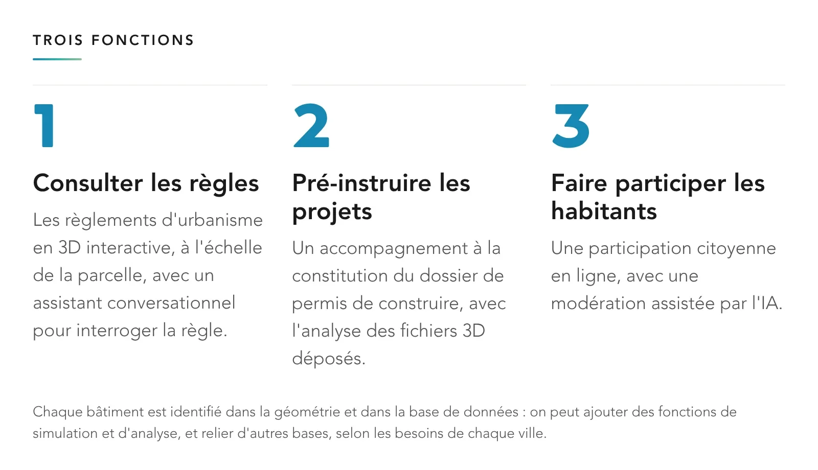
One platform covers the whole urban planning project process:
Domain expertise
Chloé Haentjens | CEO and co-founder
After ten years designing complex urban projects around the world at Foster + Partners, AECOM and SoomeenHahm Design, I founded DigiCity on one conviction: digital tools should serve the people who shape cities, not the other way round.
My expertise: bringing together regulatory planning, 3D modelling and spatial data intelligence.




Urban planner / GIS specialist
You build the regulatory engine of the digital twin, working closely with local authorities.
View roleShow less
What you will do
- Structure local planning rules (PLU, PLUi) for the regulatory engine.
- Turn these rules into 3D volumes using algorithmic methods.
- Support local authorities: needs, onboarding, user feedback.
- Integrate the land registry and regulatory layers, and check their quality.
About you
- Bachelor's or master's degree in urban planning, spatial planning, GIS or architecture.
- Recent graduate or up to 3 years' experience.
- QGIS; PostGIS, Python or parametric modelling are a plus.
- Basic knowledge of planning law.
Back-end developer
You take charge of the platform's technical core: architecture, back end, data and R&D.
View roleShow less
What you will do
- Design the architecture and the back end (APIs, data).
- Bring local data (LiDAR, land registry, GIS, regulations) into the 3D platform.
- R&D: turn the text of local plans (PLUi) into executable 3D rules.
- Connect BIM with regulatory GIS.
About you
- 4–5 years in back-end development (Python, Node.js, Go, Java…).
- PostgreSQL; PostGIS is a real plus.
- You enjoy R&D and complex business domains.
- Bonus: NLP, geospatial or 3D data.
Unreal Engine developer
You bring places to life in real-time 3D: visualisation, interface and interactivity.
View roleShow less
What you will do
- Develop the real-time 3D experience in Unreal Engine.
- Design the visualisation of the area and the interface.
- Integrate 3D and geospatial data and the project databases.
- Test with users and work with local authorities.
About you
- 4–5 years on Unreal Engine (UE4/UE5, C++, Blueprints).
- UMG / CommonUI interfaces, a feel for UX.
- Rendering performance for large scenes.
- Bonus: GIS, architectural visualisation or video games.
ApplyPlease include your portfolio with your application.
Join the DigiCity journey
Urbaniste / géomaticien
Développeur back-end
Développeur Unreal Engine
Join our team
Experience and collaboration














Get in touch
Interested in what we do? Get in touch and let’s build a digital twin that fits your area, together.